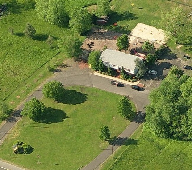
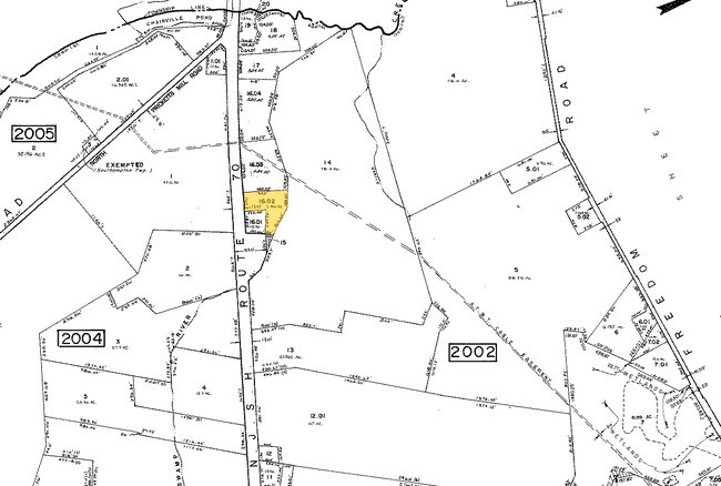
Property Record
1633 Route 70, Southampton, NJ 08088

NEARBY LISTINGS FOR SALE OR LEASE
Property Detail
1633 Route 70
33-02002-0000-00016-02
Burlington
Commercialnec
New Jersey
A
16.2
34005C0268F
2.86 AC
2024
South Burlington County
2025
Philadelphia
703202
Philadelphia-Camden-Wilmington, PA-NJ-DE-MD
3,016 SF
DEMOGRAPHICS near 1633 Route 70
1 Mile
3 Mile
5 Mile
2024 Total Population
386
12,759
50,457
2029 Population
388
12,918
51,273
Pop Growth 2024-2029
+ 0.52%
+ 1.25%
+ 1.62%
Average Age
42
43
45
2024 Total Households
138
4,898
19,562
HH Growth 2024-2029
+ 0.72%
+ 1.31%
+ 1.71%
Median Household Inc
$132,589
$125,315
$120,849
Avg Household Size
2.80
2.60
2.50
2024 Avg HH Vehicles
2.00
2.00
2.00
Median Home Value
$429,487
$381,701
$370,160
Median Year Built
1982
1976
1980
Nearby Places
Map Layers
Map Styles
 Street
 Aerial
- Restaurants
- Banks
- Shops
- Fitness
- Groceries
PUBLIC TRANSPORTATION
AIRPORT
Philadelphia International
DRIVE
WALK
Distance
Philadelphia International
45 min
31.0 mi
Trenton Mercer
DRIVE
WALK
Distance
Trenton Mercer
50 min
33.9 mi
Atlantic City International
DRIVE
WALK
Distance
Atlantic City International
74 min
40.9 mi
Freight Ports
South Jersey Port
DRIVE
WALK
Distance
South Jersey Port
28 min
19.7 mi
Nearby Properties
Address
Land Use
TOTAL SIZE
Lot Size
Zoning
Address
Land Use
TOTAL SIZE
Lot Size
Zoning
103.84 AC
PPE
Address
Land Use
TOTAL SIZE
Lot Size
Zoning
3 AC
GMN
Address
Land Use
TOTAL SIZE
Lot Size
Zoning
16.60 AC
Address
Land Use
TOTAL SIZE
Lot Size
Zoning
62.20 AC
GMN
Address
Land Use
TOTAL SIZE
Lot Size
Zoning
49.38 AC
PPE
Address
Land Use
TOTAL SIZE
Lot Size
Zoning
34.74 AC
PPE/
Address
Land Use
TOTAL SIZE
Lot Size
Zoning
22.74 AC
HC-1
Address
Land Use
TOTAL SIZE
Lot Size
Zoning
57.38 AC
PPE
Address
Land Use
TOTAL SIZE
Lot Size
Zoning
9.88 AC
PPE
Address
Land Use
TOTAL SIZE
Lot Size
Zoning
23.70 AC
HM
Address
Land Use
TOTAL SIZE
Lot Size
Zoning
1,754 SF
10.69 AC
HC-2
Address
Land Use
TOTAL SIZE
Lot Size
Zoning
17.54 AC
PPE
Address
Land Use
TOTAL SIZE
Lot Size
Zoning
23,402 SF
2.42 AC
RHO
Address
Land Use
TOTAL SIZE
Lot Size
Zoning
13.50 AC
HC-1
Address
Land Use
TOTAL SIZE
Lot Size
Zoning
1,716 SF
42.56 AC
GMN
Address
Land Use
TOTAL SIZE
Lot Size
Zoning
18.55 AC
LI
Address
Land Use
TOTAL SIZE
Lot Size
Zoning
10.36 AC
PI
Address
Land Use
TOTAL SIZE
Lot Size
Zoning
157.02 AC
VRD
Address
Land Use
TOTAL SIZE
Lot Size
Zoning
3,684 SF
8.80 AC
HC-1
Address
Land Use
TOTAL SIZE
Lot Size
Zoning
20,460 SF
23.95 AC
AR
Address
Land Use
TOTAL SIZE
Lot Size
Zoning
1.64 AC
SGRA
Address
Land Use
TOTAL SIZE
Lot Size
Zoning
4.90 AC
PPE
Address
Land Use
TOTAL SIZE
Lot Size
Zoning
17,194 SF
150.35 AC
GD
Address
Land Use
TOTAL SIZE
Lot Size
Zoning
10.65 AC
GMS
Address
Land Use
TOTAL SIZE
Lot Size
Zoning
18,362 SF
5.59 AC
RHC
Address
Land Use
TOTAL SIZE
Lot Size
Zoning
3.87 AC
PPE
Address
Land Use
TOTAL SIZE
Lot Size
Zoning
42,060 SF
15.49 AC
CC
Address
Land Use
TOTAL SIZE
Lot Size
Zoning
11.30 AC
GD
Address
Land Use
TOTAL SIZE
Lot Size
Zoning
16.60 AC
RC
Address
Land Use
TOTAL SIZE
Lot Size
Zoning
17,692 SF
17 AC
HC-2
The World's #1 Commercial Real Estate Marketplace
Connect with us
© 2025 CoStar Group
The information above has been obtained from sources believed reliable. While we do not doubt its accuracy we have not verified it and make no guarantee, warranty or representation about it. It is your responsibility to independently confirm its accuracy and completeness. Any projections, opinions, assumptions, or estimates used are for example only and do not represent the current or future performance of the property. The value of this transaction to you depends on tax and other factors which should be evaluated by your tax, financial, and legal advisors. You and your advisors should conduct a careful, independent investigation of the property to determine to your satisfaction the suitability of the property for your needs.